Local earthquake tomography between Bergen Arcs and Hardangerfjord shear zone
Hovedinnhold
Project description
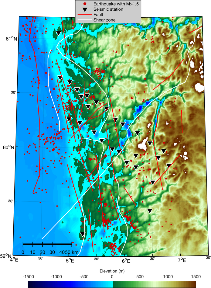
In southwestern Norway, the collapse of the Caledonian orogen and the opening of the North Sea rift have created an oblique network of shear zones and faults that offset geologic units, creating Moho jumps of the order of 10-15 km. Large shear zones associated with the post-Caledonian extension dominate in SW-NE-direction, while faults associated with the North Sea rifting dominate in N-S-direction. Some of these faults are seismically active today, such as the Øygarden fault which likely hosted the M 3.8 earthquake of 7 Nov 2017. While offshore seismic profiles show that some shear zones (e.g., Hardangerfjord shear zone) extend across the crust in the North Sea, the situation is less clear onshore where no imaging attempts have been made – especially in the enigmatic Bergen arcs and at the transition from the fault-shaped fjords to the Hardangervidda plateau. To address the lack of onshore imaging, the seismology group at GEO currently runs a densely spaced deployment of 24 seismometers for two years. The seismometers are arranged in two lines, perpendicular to the major geologic structures between the coast at Øygarden to the mountains at Røldal. The aim of this project is to obtain a 3-D seismic velocity model of the crust to provide new insight into geologic structures in the region. The project will involve (i) preparation of a dataset for local earthquake traveltime tomography (including picking arrivals and quality controlling), (ii) setting up an initial model and running the inversion, (iii) testing the robustness of obtained models, and (iv) interpretation of seismic anomalies in relation to surface observations and earthquakes in the region. The work will require an understanding of inverse theory, signal processing, computer programming, and structural geology.
Proposed course plan during the master's degree (60 ECTS):
GEOV355, GEOV359, GEOV276, and three more courses depending on background and interest
Prerequisites
The project is suitable for students with a geophysics bachelor degree. Potential candidates should have taken and passed the following courses (or equivalent): GEOV112, GEOV113, at least one of either GEOV219 or GEOV254.
External data
The candidate will work with earthquake recordings that are obtained by the seismic network operated by GEO.
Felt- lab- og analysearbeid
The seismometers deployed for this project will need to be serviced and retrieved in the fall of 2020. During this time, the student will be able to participate in one- and two-day field trips to the stations.
MAIN SUPERVISOR
Professor Lars Ottemöller, GEO, UiB
CO SUPERVISOR
Dr. Felix Halpaap, GEO, UiB
Professor Stéphane Rondenay, GEO, UiB