DAY 12: A BRIEF INTRODUCTION TO THE SEAMOUNT
10.07.2008 One of the activities on the ship has been the mapping of the sea floor. Tor Eric Svendsen has been turning his day into night and doing this job. The purpose of the mapping is both to fill in the gaps in our knowledge of the topography, and to assist the Norwegian government in determining the country’s true boundaries, which are defined as the extent of material drifting from Norway’s coast.

Hovedinnhold
text and photos by Courtney Flanagan
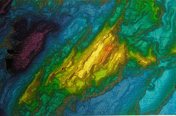
The picture is of a section of this map, the orange color indicates the shallowest place on the map: the top of the seamount we are exploring. At roughly 6-700 meters (almost half a mile) below the surface, it is still in Deep Ocean. The flat plane at the top of the seamount was most likely formed by volcanoes and then lifted up by plate movement to become an island. Ultimately, the plates began to cool and separate, and the seamount sunk back down below the surface to its present position. This whole process most likely took from one to two million years!
One of the measurements we are taking on the cruise is changes in the earth's gravity. The fact that gravity changes at all was new information for this middle-aged diarist who learned in school that one of the few constants in the world was .... gravity! I have learned on this cruise however that it does change based on the geology, and on the topography of the land, or in our case, sea floor. Hence the seamount affects gravity. Additionally, and an even stranger concept for me, is the fact that the ocean actually is NOT level. In fact, over a seamount, it forms a mini-hill. The increased gravity over the seamount sucks in the ocean and pushes it up causing a slight swelling, which is visible from satellites.
Although seamounts have been explored quite a bit off the coast of Southern Europe, this particular seamount has been virtually untouched. As a hotspot of biodiversity, seamounts are of great interest to macro biologists like Hans Tore Rapp and Paco Cardenas. As I understand it, the richness of the fauna is for several reasons. For one thing, the geology of the seamount causes upwelling of the sea water, caused in part by the fact that the seamount deflects currents. This makes a broad mix of nutrients available to the organisms on the rocks. The hard substrate itself also affects the diversity of life that can be found on the seamount, because it could serve as a "stepping stone" for the dispersal of organisms, via the current, from one seamount to another. Finally, the difference of temperature between the top plane (hovering at 0 degrees C) and the bottom (perhaps at -.75 degrees) allows for species with a variety of environmental needs. The seamount also gets a variety of temperatures from different currents coming from north and south.
The seamount's very diversity is a real threat to its continued healthy existence. Because of its rich life, it is of great interest to fishermen, who are interested in trolling the bottom (which of course destroys much of the bottom life) and fishing with long lines for fish such as halibut and other fish attracted to the seamount by the dense aggregate of plankton on its surface. Much of the Deep Ocean is essentially a desert with few large fish. The seamount however is essentially an oasis in the ocean. (We for example have been constantly on the lookout for whales, but since we have primarily been working over the deepest parts of the sea, we don't see many; there is nothing for them to eat!). Part of our goal on this expedition therefore is to explore the seamount while it is still untouched. Happily, some of these incredible areas are beginning to get protected by the countries in whose waters they fall. This particular seamount however, since it is in international waters, has a harder row to hoe before it can achieve protected status.
Each day when our ROV makes a dive, many of us watch the exploration from a top floor screening room. The video recorder on the ROV gives often extremely clear pictures which are so sharp that we are able - after we finish "ooh"ing and "ah"ing over the appearance of a new creature - to shoot them directly from the screen. Stay tuned to this web site for much more wonderful still photos taken directly from the video which will be published soon.