Comparison between strike-slip faults in the Palaeozoic and Mesozoic rocks around the Bristol Channel Basin
Hovedinnhold
Prosjektbeskrivelse / Project description
The Palaeozoic and Mesozoic rocks of SW England and south Wales are cut by strike-slip faults that are conjugate about approximately N-S. Those faults that occur in the Palaeozoic rocks have been attributed to Variscan deformation, while those in the Mesozoic rocks have been attributed to Alpine deformation. It is likely that some of the strike-slip faults in the Palaeozoic rocks might have formed or reactivated during Alpine deformation. These faults are of current interest because they may influence fluid flow in the subsurface, with significance for the ongoing geothermal projects in the region.
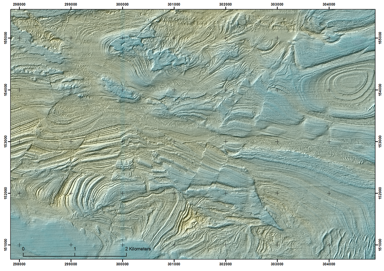
The geology of the region has been extensively studied, with large amounts of high-quality data available. Datasets include British Geological Survey maps, bathymetry data (Fig. 1) and drone data from coast exposures.
Research question: can remotely-sensed data be used to distinguish sets of strike-slip faults of different ages?
Aims:
1. Use existing data (BGS maps, bathymetry data, drone data and the literature) to determine the distributions and geometries of strike-slip faults around the Bristol Channel.
2. Determine the orientations and frequencies of strike-slip faults in rocks of different ages to see whether it is possible to distinguish between "Variscan" and "Alpine" strike-slip faults.
3. Ground-truth the interpretations from remotely-sensed data using fieldwork.
Methods:
1. Create an ArcGIS database of existing data (BGS maps, bathymetry data, drone data and the literature).
2. Analyse the data to determine the geometries, distribution and relative ages of strike-slip faults around the Bristol Channel.
3. Compare the strike-slip faults in Palaeozoic and Mesozoic rocks to see if it is possible to distinguish between “Variscan” and “Alpine” structures.
4. Ground-truth results with fieldwork and new drone data collection at selected locations. One location will be Peppercombe Beach, Devon, where the Sticklepath Fault juxtaposes Carboniferous and Permian sedimentary rocks.
This MSc project will be carried out in collaboration with staff at Plymouth University. In particular, Joe Connelly has started a PhD on the deformation and fluid flow history of the Bristol Channel Basin in October 2020. Data will be shared and staff from Plymouth will provide assistance and act as guides during fieldwork.
The student will develop the following skills:
• Analysis of the geometries and age relationships of fault systems
• Analysis of remotely-sensed data
• Use of ArcGIS
• Flying a drone to collect data and processing of the data
• Ground-truthing remotely-sensed data
Proposed course plan during the master's degree (60 ECTS):
GEOV231, Marine Geological Field and Laboratory Course (10)
GEOV251, Advanced Structural Geology (10)
* GEOV252, Field Course in Geological Mapping (10)
GEOV300, Selected Topics in Geoscience (5)
* GEOV352, Field Course in Reservoir Geology (5)
GEO215, Geographical Information Systems: Theory and Practice (10)
GEO316, Practical Skills in Remote Sensing and Spatial Analysis (10)
* In case fieldtrips are not possible, these will be replaced by GEOV302, Data Analysis in Earth Science (10) and by
GEOV364, Advanced Basin Analysis (5)
Prerequisites
BSc in geology
Field- lab- og analysis
Lab analysis of remotely-sensed data using ArcGIS
Ground-truthing in the UK for two weeks, including collection of new drone data
Supervisors
Professor Haakon Fossen (Main supervisor)
Associate Professor David Peacock (co-supervisor)