TMS-supported volcano research published in Nature Communications
Can CT scanning be used to better determine the magnitude of past volcanic eruptions? The answer is a resounding yes, according to a new study in Nature Communications by Willem van der Bilt with colleagues.

Main content
“My team and I are very excited to see our work appear in a highly visible journal like Nature Communications. It is a testament to the success of our collaboration”, says Willem Godert Maria van der Bilt.
The Earth Scientist received the TMS Starting Grant in 2021. Shortly after, he began studying the invisible traces of geohazards like volcanic eruptions in geological data. Through his research, he found CT scanning to be the most promising tool to help improve volcanic hazard assessments.
“Volcanic eruptions rank among the most destructive geohazards that affect human society. A greater understanding of the magnitude and frequency of the largest and most dangerous events will significantly improve our ability to calculate the risk of such catastrophes in the future. The nuts and bolts of doing so with CT scans ties in well with many of the methods I use for other purposes in my TMS-funded PASTFACT project”, says van der Bilt.
Out of the box
CT scanning is not usually associated with studies of volcanic eruptions, is it?
“No, it’s certainly a bit out of the box”, says van der Bilt.
Computed tomography (CT) is widely known as a medical imaging technique used to obtain detailed internal images of the body.
Although the CT scan is typically used by medical professionals to detect injuries such as bone fractures, van der Bilt and his colleagues have demonstrated that it is highly suitable for characterizing geological features as well. With a special CT scanner from UiB's Earthlab at The Department of Earth Science, they have, for instance, managed to successfully count iceberg-transported particles and detect invisible volcanic ash markers based on the unique density of these materials.
Van der Bilt explains how a CT scan can allow more accurate estimates of the size of volcanic eruptions:
“Fundamentally, a CT scan visualizes density differences. For example, between bone material and a fracture. In a vulcanological context, we are measuring the density difference between volcanic rocks and the air (pore space) between these particles. In the past, these empty spaces were added to the volume estimate of eruptions because researchers didn’t really have the possibility to quantify them properly. That led to many erroneous and inflated volume estimates. CT scans can visualize these spaces in 3D and derive information about density differences at scales invisible to the human eye. This allows us to estimate the size of past eruptions with much greater confidence.”
Approached by GEOMAR
Having heard of the impactful CT-derived findings by van der Bilt and his colleagues, researchers at GEOMAR in Kiel, Germany reached out with an offer to collaborate.
“Colleagues at GEOMAR approached me and asked whether it would be possible to use the CT approaches developed by myself and colleagues on pores instead of particles to better constrain the poorly quantified magnitude of past volcanic eruptions. We started working together last year and the answer to his question turned out to be a resounding yes. The fruits of this labor are now published in Nature Communications”, says van der Bilt.
The study was led by Dr. Jens Karstens from GEOMAR.
“Jens is an expert in seismic data interpretation and has previously used such information to calculate the volume of volcanic eruptions. For this study, he was eager to provide an independent estimate based on geological information, namely volcanic deposits in sediment cores. This was the primary focus for the work carried out with the CT scanner at UiB GEO, which was led by me”, says van der Bilt.
History’s most famous volcanic disaster
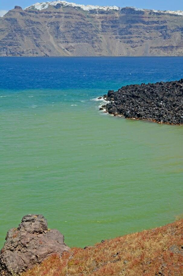
In the study, Karstens and van der Bilt chose to investigate one of the most famous volcanic disasters in human history.
We want to reach everyone interested in volcanic hazards – from historians to economists to geologists.
“We applied our new CT-based approach to recalculate the magnitude of the Minoan eruption, which destroyed the island of Santorini, created a tsunami that flooded coastal settlements throughout the eastern Mediterranean, and gave rise to the myth of Atlantis”, says van der Bilt.
He hopes their findings will reach a broad audience.
“Nature Communications is a highly regarded journal with a broad inter-disciplinary readership. Therefore, we stand a good chance to connect with the largest possible audience, so that our study has more impact. We want to reach everyone interested in volcanic hazards – from historians to economists to geologists. All these disciplines have a part to play to safeguard society.”
May redefine volcanic hazard assessments
“This has been a collaborative effort by a large group of people who have been approaching the same problem from many different angles with a range of methods. The study would not have been possible without the contributions from Earthlab engineer Jan Magne Cederstrøm, who performed all the scans, my group’s former Erasmus intern, Bolkar Kiliç, and everyone else involved”, says van der Bilt.
He does not intend to solely focus on famous volcanic disasters like the Minoan eruption in his future research.
“There are many more catastrophic eruptions from the past, whose size can be better constrained using our CT-based approach. I look forward to doing so in the foreseeable future, and I hope this work will redefine volcanic hazard assessments”, he says.
Publication
Title: Revised Minoan eruption volume as benchmark for large volcanic eruptions
Journal: Nature Communications
Authors: Jens Karstens, Jonas Preine, Gareth J. Crutchley, Steffen Kutterolf, Willem G. M. van der Bilt, Emilie E. E. Hooft, Timothy H. Druitt, Florian Schmid, Jan Magne Cederstrøm, Christian Hübscher, Paraskevi Nomikou, Steven Carey, Michel Kühn, Judith Elger & Christian Berndt