Infrastructure
NorEMSO is structured under an overarching scientific objective to better understand the drivers for the temporal and spatial changes of water mass transformations, ocean circulation, acidification and thermo-chemical exchanges at the seafloor in the Nordic Seas, and to contribute to improvement of models and forecasting by producing and making available high quality, near-real time data. NorEMSO will represent an important extension of the existing EMSO network toward the north. The network of NorEMSO in the Nordic Seas will comprise of three main components: moored observatories, underwater gliders, and an integrated seafloor-water column observatory.
Main content
Organisation

The NorEMSO structure
Each work package (WP) will be led by two different institutions in order to strengthen competence and promote institutional relations.
- WP1 (lead /co-lead): Ilker Fer and Benedicte Ferré
- WP2 (lead/co-lead): Øystein Skagseth and Ingunn Skjelvan
- WP3 (lead/co-lead): Kjetil Våge and Laura de Steur
- WP4 (lead/co-lead): Steffen Leth Jørgensen and Beatrice Tomasi
WP1 will maintain strong links with EMSO ERIC. The WP leaders and co-leaders will report progress to an executive committee, which will report to a steering committee and an advisory board.
Advisory Board is:
Juanjo Dañobeitia, EMSO director
Mairi M.R. Best, an international expert in Earth/ocean observing, Canada
Pierre Testor, Pierre and Marie Curie University, France
Moored observation systems
Svinøy
The Svinøy section is located in a confluence region cutting through the two-branched Norwegian Atlantic Current. One basically barotropic slope branch situated just off the shelf break referred to as the Norwegian Atlantic Slope Current (NwASC) and a western baroclinic jet associated with the sub-Arctic Front referred to as the Norwegian Atlantic Front Current (NwAFC). In EMSO the main objective is to continue measurements of currents in the NwASC in order to estimate the transport series of the northward-flowing Atlantic Water. A second objective is to extend transport estimated to also include the NwAFC.
Transports estimated of the NwASC based on current measurements started in 1995 operated by the Geophysical Institute, UoB. Through the years it has been part of various projects; starting out as an NRC project 1995-1997, and then continuing under EU projects VEINS and ASOF. Since about 2007 continuation of the monitoring has been secured by the personal commitment of Prof. Kjell A Orvik (at UoB) securing the funding. The transport series in the Svinøy section in EMSO is also an integrated part of the repeated hydrographic and plankton surveys performed by the Institute of Marine Research (IMR) since regularly 1977, and glider missions in the southern Norwegian Sea started under EMSO.
EMSO scientific disciplines: physical oceanography
General information
Location: From 63°N 4°E and toward northwest in the southern Norwegian Sea
Distance from land: 100 km west of Norway
Max water depth: 500 to 3000 m
Date 1st deployment: 1995-2020 (UIB), 2020 (IMR). First deployment within the EMSO framework: May 2020.
Supported by: Research Council of Norway, Norway
Operated by: Institute of Marine Research (oystein.skagseth@imr.no)
Website: https://www.uib.no/en/noremso/140162/infrastructure#moored-observation-systems
Status: EMSO mooring deployed in May 2020,
Regional Team Leader: Ilker Fer, University of Bergen (ilker.fer@uib.no)
Observatory PI: Øystein Skagseth, Institute of Marine Research (oystein.skagseth@hi.no)
Scientific objectives
In EMSO the main objective is to continue measurements of currents in the NwASC for the continuation of the transport series of the northward-flowing Atlantic Water. The main mooring – S1 – located over the 500 m isobath at 63N, 4E is found to capture the transport variability if the NwASC at time scales exceeding one month. A second objective is to extend estimates of the transport further west to also include the NwAFC. To reach this objective we use a mooring array of four additional moorings with near-bottom current meters to avoid trawling and combine these measurements with repeated hydrographic section (4-6/year) and satellite sea surface height data.
Description of infrastructure
The main mooring – S1 – located over the 500 m isobath at 63N, 4E is used to estimate transport variability if the NwASC at time scales exceeding one month. Additionally, four current meter moorings are distributed over 1000, 1500, 2000, and 2500 m isobaths. The current meters are all Aanderaa Seaguard instruments.

Photo:
Øystein Skagseth
| 
Photo:
Øystein Skagseth
|
Figure (left) Design of the S1 current meter mooring and (right) the Svinøy section hydrographic section
Station M
Station M is situated at 66°N 2°E in the Norwegian Sea. The area is dynamic with an upper layer of relatively warm and saline Atlantic Water episodically influenced by the fresher Norwegian Coastal Current. A single array deep mooring is deployed at the site.
Station M has a history back to 1948 when it started as one of 13 ocean weather stations (OWS) in the north Atlantic. The station, which is also called OWSM, was operated by weather ships until 2009, and after this, research vessels have visited the station 4-6 times a year. Discrete measurements of inorganic carbon over the full water column started in 2001, and in the years 2005-2009 and 2011-2021, pCO2 in surface water and atmosphere were measured continuously at the site. In 1994, the first deep mooring was deployed at the site, and thus, the current activity represents a continuation of long-term observations. Station M has always been a multidisciplinary site, with contributions from physical and chemical oceanography, microbiology, and meteorology. Within the frame of EMSO, physical and chemical measurements are performed at the station.
The time series from the observatory contribute to an improved understanding of short- and long-term variability of water masses and ocean biogeochemistry in the area.
EMSO scientific disciplines: physical and chemical oceanography
General information
Location: at 66°N 2°E in the Norwegian Sea
Distance from land: 236 NM – 430 km from the Norwegian coast
Max water depth: 2050 m
Date 1st deployment: 1948 (first measurement); 1994 (first mooring); 2020 (first mooring within the EMSO framework)
Supported by: Research Council of Norway, Norway
Operated by: NORCE Norwegian Research Centre and University of Bergen
Website: https://www.uib.no/en/noremso/140162/infrastructure#moored-observation-s...
Status: EMSO mooring deployed and replaced annually
Regional Team Leader: Ilker Fer, University of Bergen (ilker.fer@uib.no)
Observatory PI: Ingunn Skjelvan, NORCE (insk@norceresearch.no)

Photo:
UiB
| 
Photo:
NORCE
|
Left: Sketch of the mooring at Station M; right: warming of the deep water over the years 1948 to 2022 (modified from Østerhus and Gammelsrød, 1999).
Scientific objectives
Short- and long-term variability of the inorganic carbon cycle and hydrography are monitored at Station M. From this, ocean acidification and its variability are determined. The aim is to increase our knowledge on which processes are driving the observed variability of the inorganic carbon cycle and in particular ocean acidification. The long time series from the station contributes to a better understanding of the climate system and its variability.
Description of the infrastructure
The observatory consists of a single mooring between 500 and 2050 m depth, with sensors for temperature, salinity, pressure, and pCO2 measurements. Measurements of dissolved oxygen will be included. The first EMSO mooring was deployed in August 2020, and it is replaced once a year, usually in early fall.
Data are downloaded after retrieving the sensors and made available after quality control.
References
Østerhus, S. and T. Gammelsrød, 1999, The abyss of the Nordic Seas is warming, J Climate, 12, 3297-3304.
South Cape
More than thousands seepages of methane, potent greenhouse gas that could enhance climate warming if it reaches the atmosphere, cover the Norwegian and Svalbard continental margins. In particular, a gas hydrate pingo located south of Svalbard is persistently emitting natural gas. Methane bubbles are rising as high as 20 m below the sea level at this location. In EMSO Nordic Sea, the observatory South Cape will consist of a seabed and water column observation aiming at monitoring the methane seepage activity and transport in the water column. In addition, it will monitor oceanographic processes from the seafloor to the sea surface.
Nordic Seas- South Cape scientific disciplines: geosciences, physical oceanography, biogeochemistry

Bathymetry of the gas hydrate pingo area. The white lines represent bubble streams. Credit: Manuel Moser (PhD at UiT The Arctic University of Norway)
General information
Location: at 76.107°N 15.967°E, off South Cape of Svalbard, gas hydrate Pingo
Distance from land: 28 NM – 52 km from western coast of Svalbard
Max water depth: 390 m
Date 1st deployment: December 2021(planned)
Supported by: Research Council of Norway, Norway
Operated by: UiT The Arctic University of Norway
Website: https://www.uib.no/en/noremso
Status: in development
Regional Team Leader: Ilker Fer, UiB (Ilker.Fer@uib.no)
Observatory PI: Bénédicte Ferré, UiT The Arctic University of Norway (benedicte.ferre@uit.no)
Scientific objectives
The scientific objectives are to estimate i) the seasonal and inter-annual variability of methane release from an intense methane release site south of Svalbard; ii) how high methane is transported; iii) the influence from oceanic setting in this potential variability.
Description of the infrastructure
The infrastructure will use an existing seafloor observatory (K-lander) along with a water-column mooring. Both components will be equipped with physical and chemical sensors (hydrophone, ADCP, CTD, pH, CH4 and CO2 sensors). The deployment is scheduled in December 2021 to be confirmed.
Fram Strait
The central Fram Strait mooring (F10) is deployed at 78.83°N, 2°W. It captures the recirculating Atlantic Water in the Fram Strait which merges with the East Greenland Current (EGC) to flow southward. The upper-ocean here is marked by the Polar-Atlantic Waterfront and shows alternating fresh and cold Polar Water coming from the EGC and warm and saline Atlantic Water arriving from the West Spitsbergen Current (WSC). The flow is west-southwestward and is significantly stronger in winter, driven by stronger wind forcing over the Greenland Gyre in winter. The returning Atlantic Water gets denser as it gets cooled and is the source water for the Denmark Strait Overflow further south.
The mooring F10 was installed and maintained by the Alfred Wegener Institute (AWI) in 1997- 2002 at 79°N and between 2002-2016 at 78.83°N. From 2017-2020 it was maintained at 78.83°N by the Norwegian Polar Institute (NPI). As of 2020, it will be continued by the NPI within EMSO. Within the framework of EMSO, chemical measurements, DO and pH/pCO2, are included at the station as of 2020 and 2021 respectively.
EMSO scientific disciplines: physical oceanography, chemical oceanography
General information
Location: 78.83°N 2°W in the Fram Strait
Distance from land: 280 km west of Svalbard
Max water depth: 2655 m
Date 1st deployment: 1997-2016 (AWI), 2017-2020 (NPI). First deployment within the EMSO framework: August 2020.
Supported by: Research Council of Norway, Norway
Operated by: Norwegian Polar Institute - Laura de Steur
Website: https://www.uib.no/en/noremso/140162/infrastructure#moored-observation-systems
Status: EMSO mooring deployed in August 2020
Regional Team Leader: Ilker Fer, University of Bergen (ilker.fer@uib.no)
Observatory PI: Laura de Steur, Norwegian Polar Institute (laura.de.steur@npolar.no)


Scientific objectives
The station monitors the hydrographic and current properties of the return Atlantic Water and the eastward extension of the Polar Water in the EGC, allowing to quantify the relationship between atmospheric forcing and sea ice presence with the upper ocean variability. Through added parameters DO and pH/pCO2 it will be possible to quantify year-round variability in ocean chemistry and the relationship with physical oceanography. Long time series will contribute to a better understanding of long-term changes and trends in the ocean and climate system.
Description of the infrastructure
The observatory has a history in hydrographic and current measurements dating back to 1997. Instruments measuring temperature, salinity, pressure (Seabird SBE37 or RBR CTD) are mounted at nominal depths of 55-75 m (the front of Polar and Atlantic Water), 250-275 m (Atlantic Water), and at 2600 m (Deep Water). The DO and pH/pCO2 instruments are installed in the upper ocean at ±55-75 m as of 2020/2021. An upward-looking 300 kHz RDI ADPC is installed at 55-75 m while at larger depths single-point Nortek Aquadopp current meters are installed. The mooring will be serviced each year in August-September during the annual cruise of the Norwegian Polar Institute to the Fram Strait to service the Fram Strait Arctic Outflow Observatory.
Glider observation systems
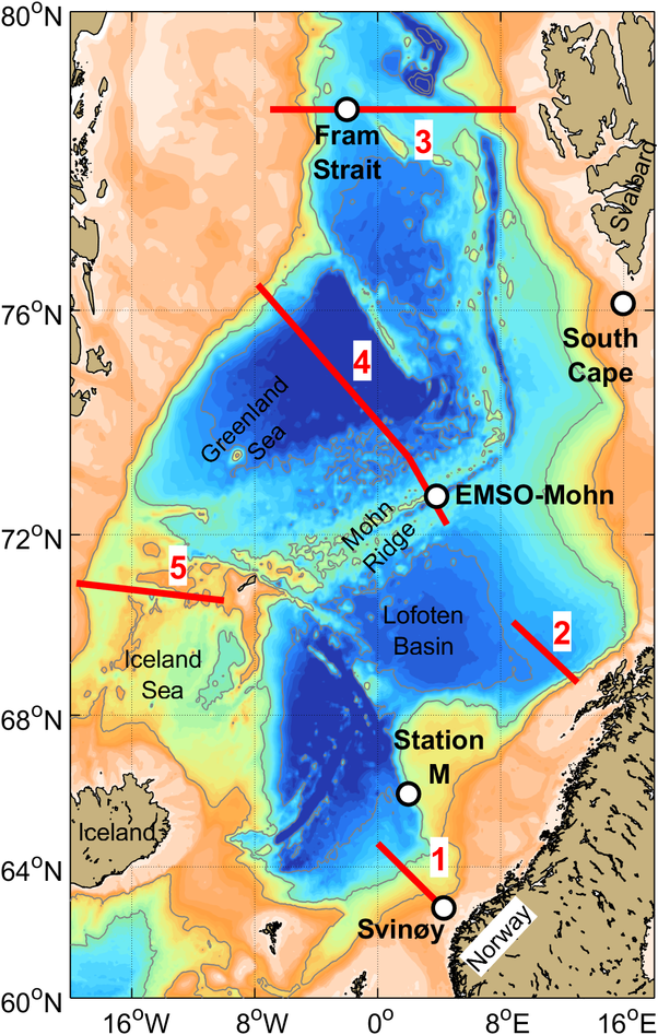
Gliders will be operated to monitor circulation and water mass properties at key locations in the Nordic Seas (Figure 1). The eastern transects 1 and 2 (Svinøy and Gimsøy) are focused on the Norwegian Atlantic Current. These transects are part of a long-term hydrographic monitoring program, where measurements at Svinøy date back to the 1950s. Transect 3 (Fram Strait) fills the observational gap in the central Fram Strait and monitors properties and variability in the return Atlantic Water along the Polar Front in the northern Nordic Seas. Transects 4 and 5 from the interior Greenland and Iceland Seas toward the east Greenland shelf monitor wintertime open-ocean convection in the western basins of the Nordic Seas and the southbound transport of cold, fresh surface water from the Arctic Ocean and dense water that feeds the lower limb of the Atlantic Meridional Overturning Circulation in the East Greenland Current, as far inshore as the ice edge east of Greenland permits.
The gliders measure temperature, salinity, and pressure.
EMSO scientific discipline: physical oceanography
General information
Locations: Transect 1 – Svinøy: 62.7°N, 4.4°E - 64.7°N, 0.0°E
Transect 2 – Gimsøy: 68.8°N, 13.0°E - 70.2°N, 8.8°E
Transect 3 – Fram Strait: 78.8°N, 9.0°E - 78.8°N, 7.0°W
Transect 4 – Greenland Sea: 73.5°N, 2.0°E - 76.4°N, 7.8°W
Transect 5 – Iceland Sea: 70.6°N, 10.0°W - 71.0°N, 19.6°W
Distance from land: Variable
Max water depth: Variable
Date 1st deployment: 2020 (gliders within the EMSO framework)
Supported by: Research Council of Norway, Norway
Operated by: University of Bergen, Norwegian Polar Institute, and Institute of Marine Research
Website: https://www.uib.no/en/noremso/140162/infrastructure#glider-observation-systems
Status: Full deployment will commence in summer 2021
Regional Team Leader: Ilker Fer, University of Bergen (ilker.fer@uib.no)
Observatory PI: Kjetil Våge, University of Bergen (kjetil.vage@uib.no)
Scientific objectives
The main purpose of the glider transects is the long-term production of high-quality hydrographic measurements across the Nordic Seas. The data will be assimilated into weather prediction models, and delayed mode data will be used for the validation of ocean models. The eastern glider transects sample the Atlantic domain of the Nordic Seas, in particular the Norwegian Atlantic Current. The western transects sample the deep water formation regions of the Greenland and Iceland Seas and, partly, the southbound flow along the east Greenland slope.
Description of the infrastructure
Three different types of gliders operate along the transects:
| Glider | Transects | Endurance | Sensors |
| Rechargeable Slocum G3 | Svinøy (1) and Gimsøy (2) | 2-4 months | Temperature, salinity, and pressure |
| Endurance Slocum G3 | Fram Strait (3), Greenland Sea (4), and Iceland Sea (5) | 10-14 months | Temperature, salinity, and pressure |
All gliders measure temperature, salinity, and pressure, while depth-averaged velocity is derived from the difference between the glider’s velocity over ground and its velocity through the water.
New Slocum gliders were acquired in fall 2020 and trial deployments were commenced later that year. Following firmware upgrades, all transects will be in full operation from summer 2021 onward.
The rechargeable gliders will be serviced during monitoring cruises in the Norwegian Sea. The endurance gliders will be serviced during annual cruises to the EMSO Mohn mooring at Fåvne (Figure 1). Decimated profiles are transmitted from the gliders at every surfacing. The full set of measurements will be downloaded from the gliders when they are serviced and made available after quality control and calibration.
Link to the Data from ongoing glider missions.

Our glider fleet. In the picture, left to right: Kjetil Våge, Ilker Fer, Fiona Elliott and Algot Peterson
EMSO Mohn
General information
Location: 72.756°N, 3.834°E at the Mohn’s Ridge (Fåvne vent field)
Distance from land: 325 NM – 600 km from western coast of Norway
Max water depth: 3050 m
Date 1st deployment: Summer 2023
Supported by: Research Council of Norway, Norway
Operated by: University of Bergen (UiB)
Website: https://www.uib.no/en/noremso/140162/infrastructure#emso-mohn
Status: deplyed
Regional Team Leader: Ilker Fer, University of Bergen (ilker.fer@uib.no)
Observatory PI: Steffen Leth Jørgensen, University of Bergen (Steffen.Jorgensen@uib.no)
Scientific objectives
EMSO Mohn is an observatory at the hydrothermal vent field Fåvne at the Mohn Ridge. The observatory will be a fixed-point seabed-water-column-coupled observatory with a multidisciplinary approach – from geophysics and physical oceanography to ecology and microbiology. Fåvne vent field is an ultramafic-hosted hydrothermal system located on the ultra-slow spreading Mohn’s ridge where the oceanographic front between the cold waters in the Greenland Sea and the warm waters in the Norwegian Sea meet. It is primarily directed at understanding the dynamics and magnitude of the coupling between the hydrothermal plume, rough bathymetry and oceanographic processes and its impact on the biosphere and surrounding water masses in the Nordic Seas.
Description of the infrastructure
The observatory was deployed in June 2023, it can be operated for 2 years. It is composed of one deep-ocean water-column mooring coupled with a seafloor node (lander). The lander relays data (hydrothermal, background seawater and oceanographic properties -e.g., pressure, temperature, turbidity, current-, and system status, some current velocity and direction) to a surface unit deployed from a boat. 15 temperature sensors are distributed across the mooring line, together with three DPUs integrating a CTD and a turbidity sensor. At about 2650 m depth the first looking downward ADCP Nortek Signature 500 is deployed. The nominal range is 70 m. A few meters above a looking upward ADCP Nortek Signature 500 is deployed. Both ADCPs are operated in Average mode to collect data on current directions and velocities but burst mode can also be implemented. This data will then made available through the EMSO data center hosted at the University of Bergen, Norway. The observatory can be complemented with autonomous seafloor instruments.


See our Data from ongoing glider missions.