Study of glacial lake outburst floods in Bhutan
My project is about remote sensing of glacial lake outburst floods (GLOFs) in the Bhutanese Himalaya range between the 1990s to present day.
Main content
I am a physical geographer master student at UiB and my project is about investigating different remote sensing methodologies like; calculating the geodetic glassier mass balances, using normalized cross-correlation to calculate glacier velocities, and using time series analysis of multispectral and radar data to assess glacier and glacier lake area changes.
All these methods will be used to study the hazards of GLOFs in Bhutanese Himalaya, to develop a time frame from the 1990s and up to present day time, and create a GLOF risk assessment.

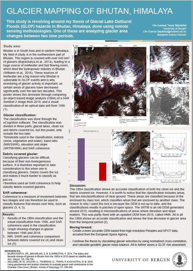
Figure 1: An overview image of my study area, north-western part of Bhutan. What is worth to notice is the complex structure of the glacier, which consist both of clear blue ice in the north and debris-covered glacier in the south. Which leads to a challenge when it comes to classify the glacier and calculate the change in area.

Figure 2: A classification of a glacier from my study area. The classification is displayed on a satellite image from 2018 (Landsat 8), and shows a classification from both 2018 and 1996, which reflects an area change of the glaciers in Bhutan over this time period.
Data processing as fieldwork
My thesis consist of just remote sensing, so there is no need for me to travel to Bhutan, Himalaya, even if I wanted to. Therefore my "fieldwork" was collaborating around data processing through different GIS software's, such as; ArcMap, eCognintion, SNAP and geomatica. Which, even if you are used to computer programming and coding, can be challenging from time to time, and I planed for it to be so. Experience wise, I learned that having access to extended harddrives and/or servers was very useful. Since you do process quite a bit of data and you will need to store them somewhere, so having access to an harddrive which is a couple of terabyte large, is very wise if you are working with a similar project.
How do you experience studying geography in Bergen?
I find studying geography in Bergen to be very exciting and fun, as I can combine both the nature outside with collaborating work inside. UiB has very good supervisors and excellent teachers who are there to help you with questions and problems.
Advice for students who consider studying here
Don't expect to know your master project just as you arrive, you will have good time to think and collaborate about them with teachers and other students. I even changed my master project mid 1st semester, as I wanted to focus more on the GIS part and not the theoretical geography part, which was sorted out smoothly and nicely.
Supervisor