Prehistoric megafloods smaller than assumed
Mighty floods have carved out deep canyons on Earth. New research suggests this may have required less power than previously thought. Collecting such data, however, may be demanding.

Main content
“We applied so much force that the raft almost folded up like a clam”, says Willem van der Bilt.
He recalls a quiet September day in northern Iceland in 2018. On a little lake named Ástjörn, he and a colleague stood on a raft consisting of a metal platform on top of a rubber boat. A third colleague had been sent to shore, while the two researchers from the Bjerknes Centre for Climate Research and the Department of Geoscience at the University of Bergen struggled to complete their job.
Below them, a plastic tube had been pressed five meters into the lake sediments, deep enough to cut through five thousand years of deposited clay and sand. Deep enough to be stuck.
This was the kind of work they had done many times before. Sediment samples from the bottom of the ocean and from lakes are one of the most important data sources for paleo climatologists. Layer by layer, mud and rotting plants settle at the bottom, the oldest material farthest down and younger material on top – building an archive of everything the water has held for thousands of years.
This time, the conditions were unusual. The tube was stuck in volcanic ash, and the metal raft groaned and moaned.
“We pressed on the sediment core with a car jack, while anxiously looking at the shoreline and asking ourselves: can we swim fast enough to reach it”, says Willem van der Bilt. “It was quite terrifying.”
Found remnants of megafloods
With a jolt, the tube with the core came out, and the raft held. Their effort was not in vain. Inside the tube, they found evidence of three major floods that have changed the landscape more drastically than one might thing they had the power to do. The floods were great, but not that great.
The results were published in the journal Communications Earth & Environment today, by Willem van der Bilt and colleagues from the Bjerknes Centre for Climate Research, the University of Bergen, Manchester Metropolitan University, Royal Netherlands Institute for Sea Research, Utrecht University and Liverpool John Moores University.
The researchers conclude that deep canyons and gorges may have been formed by less voluminous floods than previously thought. As an implication, running water can also do more harm than assumed. This makes the results important far beyond a sparsely populated region in northern Iceland.
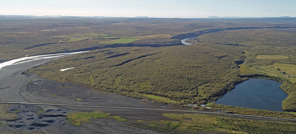
The riverside lake
Ástjörn was not part of their original travel plan. Willem van der Bilt calls it a side project of a side project. The scientists were in northern Iceland to do field work for another project. They had completed the job when they came over this little lake on the map.
Once the idea was planted, they had no reason not to go there. They were already driving around with several meters’ long coring equipment on the roof of their car.
Ástjörn is located downstream of one of the mightiest waterfalls in Europe, Dettifoss, in the river Jökulsá á Fjöllum. The name means glacier river from the mountains. Through deep canyons, this river leads meltwater from the northern side of Europe’s second largest glacier, Vatnajökull, to the ocean on the northern side of Iceland. Through the ages, whirling flood water has carved out gorges, in some places almost a hundred meters deep.
But Ástjörn is not part of the river, which is why it attracted Willem van der Bilt. The lakes they had already examined, are regularly fed with meltwater from Vatnajökull. Ástjörn is located on a plateau at the side of and above Jökulsá á Fjöllum, separated from the river plain by a high headwall.
“It occurred to me that if the river should overflow, flood sediments would collect in the lake”, he says. “Only afterwards did we realize that this a significant research setting on a particular topic: megafloods in Iceland.”
The barrier blocking the entrance to Ástjörn lies 30 meters above the river plain. Not even the most energetic spring floods reach that high. Volcanoes, breaking ice dams and flushing glacier water are needed. A flood occurring once every thousand years requires a jökulhlaup.
Flashfloods from the ice
If there had been people on Iceland 3500 years ago, they might have noticed white smoke over Vatnajökull. Water vapor rose and condensed into clouds of tiny droplets. Hours, days or weeks later, the smoke had turned gray, and large lumps of ash settled in a depression in the ice surface.
Glaciers are not immovable, and for Vatnajökull, neither is the ground below. There are active volcanoes, and during eruptions heat melts the glacier ice above. Huge lakes build up, dammed by the glacier. The water level rises, and when the ice dams eventually break, water rushes down through the rivers. Such floods are called glacial lake outburst floods, or by their Icelandic name, jökulhlaup, as if the glacier itself came running down the mountain.
The flow of water can last for a few hours or days. This happened 3500 years ago and several times before and after – altogether enough to carve out the canyon that splits the landscape surrounding Jökulsá á Fjöllum.
If the flood is really large, water can cross the barrier at the northern side of Ástjörn.
Like cement
Back in the lab in Bergen, Willem van der Bilt opened the sediment core and split it in two halves. Three distinct, gray layers could be seen between silt, sand and remnants of plants.
“It looked like cement”, he says. “We could immediately see that these were flood sediments.”
The flood sediments are fine dust, ground from the volcanic bedrock below Vatnajökull. Laboratory analyses showed that they ended up in Ástjörn during floods about 1350, 1500 and 3500 years ago.
Paleo scientists often use carbon to date old material. In Iceland, carbon dating is complicated. The volcanoes spew CO2 into the air, and as the surroundings take up carbon from this gas, the timeline is disturbed. But volcanic eruptions may also be used as a timekeeper.
In the sediments in Ástjörn were tiny glass particles that could be traced to specific, documented eruptions in Iceland. That the river had flooded these three times, was already known, but the volcanic particles made it possible to determine the time more accurately.
An Icelandic Mississippi
As they had found sediments from these giant floods in the normally disconnected lake Ástjörn, they could calculate the amount of water that had carved out the canyon in Jökulsá á Fjöllum. The number they came up with, was far smaller than previously assumed.
Even though Ástjörn and its surroundings was new territory for Willem van der Bilt, he soon discovered that other scientists had already examined the floods and the canyons of Jökulsá á Fjöllum. Hydrological simulations of flood levels in the river existed, and it was known when different parts of the deep gorges had been formed. During the most extreme floods, the canyon has been excavated so intensely that the location of the Dettifoss waterfall has moved far upwards in the river. Such changes had been dated.
Flood simulations made available, showed that water flows into Ástjörn when the discharge in the river reaches 20 000 cubic meters per second, about as much as in the Mississippi or the Brahmaputra. Such floods had dumped the cement-like sediments the researchers had found – floods large enough to allow water to cross the threshold on the northern side of the lake.
If the discharge exceeds 130 000 cubic meter per second, water can also enter Ástjörn from the south. A powerful waterfall would then flush away most of the sediments already there. Any signs of such an event were not seen in the five thousand years of data covered by this sediment core.
Thus, Willem van der Bilt and his colleagues could conclude that the three floods, in their most violent seconds, had brought between 20 000 and 130 000 cubic meters of water through the gorges of Jökulsá á Fjöllum.
That is less than one third of the previous estimates of the current required to create those gorges. Obviously, the water has been scouring more efficiently than assumed.
Water becomes a grinding machine
When the lakes below Vatnajökull break through the ice dam, not only water, but also masses of sand and clay flow down the riverbed.
“The river acts like sandpaper”, Willem van der Bilt explains.
The drifting sand allows flood water to grind off more rock than pure water could have done.
What kind of mineral that meets the water, also matters. In Jökulsá á Fjöllum lava has solidified to form basalt columns. When huge amounts of water flows around and above these columns, they break, topple over and are dragged away by the current. In this way, canyons and gorges are carved out more quickly than they would if the bedrock was to be eroded grain by grain.
Willem van der Bilt’s findings confirm what computer simulations have shown in recent years. Less water than assumed is needed to make significant marks in the landscape. This has also been observed in seasonal floods. This study is the first to document that it is also the case for megafloods occurring only once per millennium.
Like another planet
“Without the plants, Iceland would almost look like Mars”, says Willem van der Bilt.
Ástjörn is surrounded by pasture, birch and willow, but under the green cover, the landscape resembles that of our neighbor planet. The canyons on Mars are signs of a past with megafloods, events we must compare to rivers on Earth to know the extent of.
“I’d love to go to Mars on field-work, but I don’t see that happening anytime soon”, Willem van der Bilt laughs.
Iceland can be reached in a few hours. There are few places in the world where geologists can get closer to the powers of nature. Floods of the extent described in the new study, do after all occur as frequently as one in a thousand years. Not many decades pass between the lesser outburst floods from Vatnajökull, and in 1996 a pretty large flood occurred. But even though the water came close in 1725, floods have never reached Ástjörn in historic times.
Willem van der Bilt’s megafloods are marks in a sediment core and numbers from a computer model. Dry remnants of water that once flowed. Seeing a real megaflood from a helicopter would be something else. So, if it occurred again?
«I’d go», he says. «From the safety of an aircraft, and knowing that people on the ground are out of harm’s way, I’d love to see a piece of the action. I’d totally go.»